Friday, August 2, 2019

Acadia National Park Beehive and Precipice Trails - Terrifyingly awesome treks up the mountains!

I've had a lifelong fear of heights. When I was in Mt Hua in China a decade ago I found myself unable to hike the mountain because of the exposed drop offs. My legs were shaking and I was badly scared. 

So when my wife wanted to do beehive I felt incredibly nervous about it. I quickly looked at all the youtube videos, identified all the dicey parts, and watched them over and over so I could imagine myself doing them. The parts that involved climbing up rungs were no issue for me, but it was the exposed ledges that looked scary. 

Having familiarized myself with the trail beforehand, when it came time to do it we zipped up it. According to go pro footage total time taken was 16 minutes. It was enjoyable, but short hike. A few parts on the ledges I did have to slow down but I wasn't anywhere near as scared as I thought I'd be. It was like a fun obstacle course! Depending on your athletic condition it may take you longer to do the trail. I would recommend some amount of physical fitness. For beehive, if you can do ONE full body weight unassisted pullup and ONE full body weight dip then you're good to go, as you will need to use these motions to climb up the trail (at least I found they were helpful). 

The more cardio conditioning and weight training you do, the faster you'll go up the trail and the more fun it will be. That's how I was able to enjoy this hike - by treating it as a workout. It ended up being nowhere near as bad as the videos made it look. You are rewarded with great views all throughout the trail. You can see a marsh, the beach, plus the lake. In fact it was so fun that I immediately wanted to do precipice trail next, with no prompting from my wife.

Oh one more thing, once you're at the top, you're not supposed to go back down the way you came. There's a leisurely trail back down. Take it all in at the top! 


This hike was so much fun, that we immediately followed it up with Precipice trail. During my "research" (being terrified) into Beehive, I saw a lot of people posting about Precipice as well. Precipice sounded even more horrifying. But since Beehive turned out to be a fun adrenaline packed adventure, I was ready to do Precipice. Sadly, someone died on the trail a few years ago. But we were ready and excited anyway.

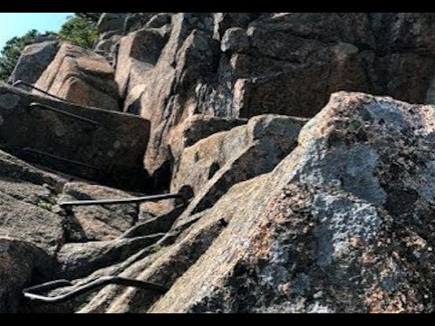
Precipice is far more difficult but even more rewarding. There are ladder rungs where you literally climb straight up the mountain. Definitely be able to do ten unassisted pullups, or you're going to struggle near the end! 


Sunday, September 7, 2008

Sauk Mountain

sauk mountain - Share on Ovi

Near: Sedro Woolley, WA
Distance: 4.2 miles round trip
Elevation Gain: 1040 ft
Hike Time: 2.5 hours
Difficulty: Easy

Directions:
From I-5 north of Mt. Vernon, go 40 miles east on Hwy 20 (North Cascades Highway). Just before Rockport State Park, turn left onto Forest Road 1030 (also known as the Sauk Mountain Rd.) . Follow this gravel road 8 miles to the trailhead parking lot. Beware the many potholes. (Lat:48.52117 Lon:-121.607)

When we went on the trail the weather was kind of cloudy, which actually worked to our benefit, since there was a beautiful fog that covered the whole trail, giving it a mystical gothic type look:

sauk mountain - Share on Ovi


sauk mountain - Share on Ovi

sauk mountain - Share on Ovi

sauk mountain - Share on Ovi

sauk mountain - Share on Ovi


The trail starts off in the meadows and winds up the mountain in a series of long switchbacks. There is a lookout at the top that gives a very good view of Sauk lake:

sauk mountain - Share on Ovi


The trail is very popular and the path to the lookout is very narrow, so it will get cramped and congested at times as people try to pass one another.

Sunday, July 20, 2008

Ashland Lake trail


Distance: 3.5 miles one-way
Elevation Gain: -370 feet (2400 feet 2030 feet)
Difficulty: Easy (Currently Medium difficulty due to snow)
Near: Mountain loop highway, by Granite falls (Northern Washington)

Directions: Get to the Verlot Public Service Center which is located along the mountain loop highway at 33515 Mountain Loop Hwy, Granite Falls, WA 98252. From the Verlot Public Service Center, travel east on the Mt. Loop Highway for 4.5 miles. Turn right on the Schweitzer Creek Road #4020. Continue 2.3 miles to the Bear Lake Road #4021 and follow this road for 1.5 miles to the junction with Road #4021016. Turn left and follow this road to end.

The road to the trailhead is gravel and has many potholes. Also, there are two trails leading off from the trailhead which can cause some confusion. One is a logging road, the other is the actual trail. The Ashland lake trail trail will have an information board at the start.

It is July 2008 and many of the trails on the mountain loop highway are still closed due to snow. Luckily, the Ashland lake trail was open, so we decided to give it a try.

Ashland lake trail consists of a relatively tame upward trek which leads to Upper 7 acre Upper Ashland lake, and then a steep downward trek which goes to the larger 12.9 acre Lower Ashland lake (hence the negative elevation gain). The trail is normally ranked as easy. However, due to the heavy snow in 2008, the trail can be difficult to traverse in certain areas. My friends and I all tripped and fell; One of my friends even fell face first on an icy log stump. One particularly bad spot was the following broken bridge which was highly unstable:


It was also easy to lose sight of the trail in the snow. The potential to get lost is definitely there.


Upper lake:


Lower lake:


Some fauna on the trail:


Monday, June 30, 2008

Barclay Creek Trail #1055


Distance: 2.2 miles one way
Elevation Gain: 300 feet (2200 feet to 2500 feet)
Difficulty: Easy
Near: Skykomish, along highway 2.

Directions: Drive State Route 2 to Baring. In the town of Baring, turn north onto Barclay Creek Road #6024. The road is directly across from "Der Baring Store." Cross the railroad track and continue for 4.0 miles to the trailhead.

Barclay Creek Trail is an easy hike and thus a good choice for beginners or those looking for a "warm up" hike to start off the season, before tackling the more difficult trails. It is located in the Mt Baker Snoqualmie Nation Forest and is part of the Skykomish Ranger district.

The trailhead is accessed via a 4 mile narrow gravel road. Parking is sparse, so be prepared to walk some distance to the trailhead, as this hike is very popular.

The trail follows the Barclay creek all the way to Barclay lake. It is a straightforward trek with no switchbacks. There are a few boardwalks and one log bridge that spans the creek. Backpackers will find plenty of campsites by the lake.


Acadia National Park Beehive and Precipice Trails - Terrifyingly awesome treks up the mountains!

I've had a lifelong fear of heights. When I was in Mt Hua in China a decade ago I found myself unable to hike the mountain because of th...